We use cookies to ensure our site functions properly and to store limited information about your usage. You may give or withdraw consent at any time.To find out more, read our privacy policy and cookie policy.
Manage Cookies
A cookie is information stored on your computer by a website you visit. Cookies often store your settings for a website, such as your preferred language or location. This allows the site to present you with information customized to fit your needs. As per the GDPR law, companies need to get your explicit approval to collect your data. Some of these cookies are ‘strictly necessary’ to provide the basic functions of the website and can not be turned off, while others if present, have the option of being turned off. Learn more about our Privacy and Cookie policies. These can be managed also from our cookie policy page.
Strictly necessary cookies(always on):
Necessary for enabling core functionality. The website cannot function properly without these cookies. This cannot be turned off. e.g. Sign in, Language
Analytics cookies:
Analytical cookies help us to analyse user behaviour, mainly to see if the users are able to find and act on things that they are looking for. They allow us to recognise and count the number of visitors and to see how visitors move around our website when they are using it. Tools used: Google Analytics
Share Downtown Trail Plan on FacebookShare Downtown Trail Plan on TwitterShare Downtown Trail Plan on LinkedinEmail Downtown Trail Plan link
We're looking for your feedback on the draft map for the Downtown Trail Plan!
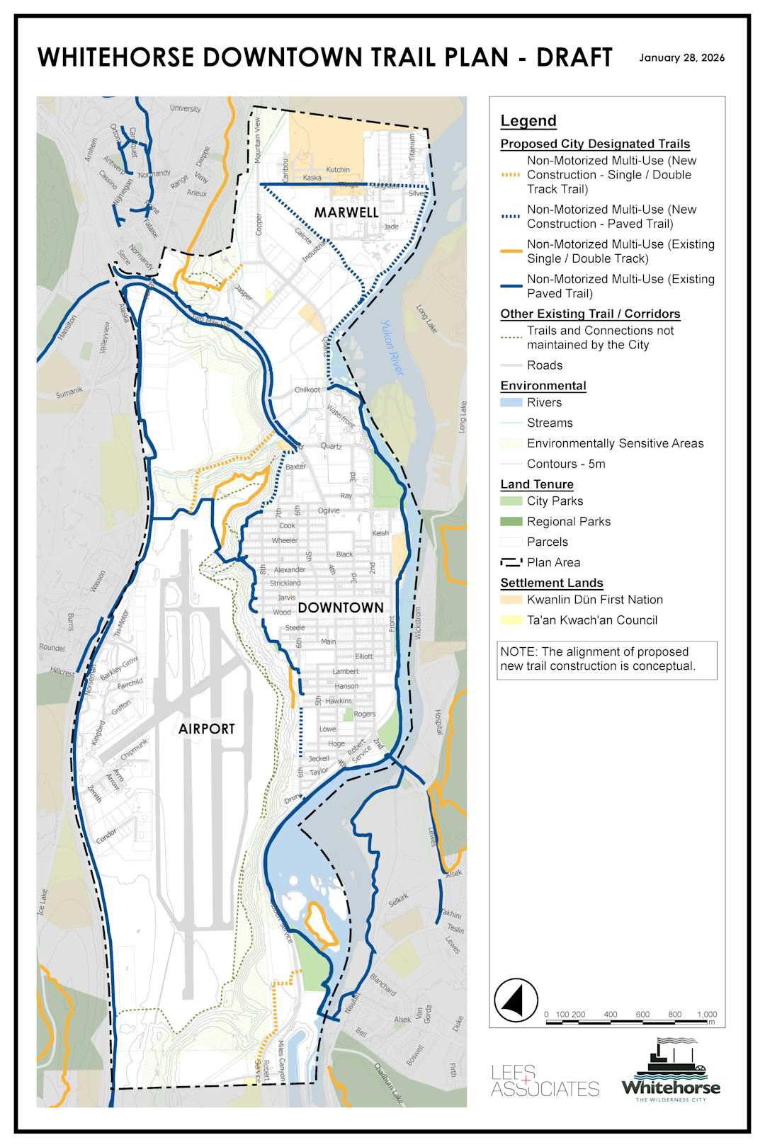
Building on the 2020 Trail Plan, and other planning documents, we're developing a neighbourhood-level Downtown Trail Plan. In 2024, the Transportation Master Plan was completed, which includes the proposed paved trail development in Downtown and Marwell as displayed on the Downtown Trail Plan map. In coming years, the City will also initiate both a Marwell South Master Plan and Riverfront Plan to create modernized planning frameworks for future use and management of these areas, while integrating existing planning efforts.
When completed, the Downtown Trail Plan will show the network of existing and planned City Trails. A key aspect of the Plan is the application of the different trail designations to trails in the network. Please view the glossary on this page for descriptions of each trail designation.
The objective of the plan is to create a coherent and sustainable trail network that provides amazing recreation and active transportation opportunities for the community and visitors. We are looking for input on how you use the Downtown area trails, as well as your feedback on the draft version of the Downtown Trail Plan. Help us ensure that the Whitehorse Downtown Trail Plan reflects the community’s needs and aspirations for trails. Let us know what you think!
You can provide your input via our online survey (availableuntil February 26), and/or attend our drop-in open house at the Frank Slim Building at Shipyards Park (100 Ogilvie Street) on February 19 from 4:30 to 7:00 pm. You may also send feedback by email with the subject line “Downtown Trail Plan” to trails@whitehorse.ca.
What we're asking now This phase of engagement focuses on sharing information and receiving feedback from residents of Whitehorse on the draft version of the Downtown Trail Plan.
Open House Thursday, February 19, 2026 Frank Slim Building, Shipyards Park (100 Ogilvie Street) 4:30 to 7:00 pm Please stop by!
Our promise to you We will keep you informed, listen to and acknowledge your concerns and preferences, and provide feedback on how public input influenced the decision.
We're looking for your feedback on the draft map for the Downtown Trail Plan!
Building on the 2020 Trail Plan, and other planning documents, we're developing a neighbourhood-level Downtown Trail Plan. In 2024, the Transportation Master Plan was completed, which includes the proposed paved trail development in Downtown and Marwell as displayed on the Downtown Trail Plan map. In coming years, the City will also initiate both a Marwell South Master Plan and Riverfront Plan to create modernized planning frameworks for future use and management of these areas, while integrating existing planning efforts.
When completed, the Downtown Trail Plan will show the network of existing and planned City Trails. A key aspect of the Plan is the application of the different trail designations to trails in the network. Please view the glossary on this page for descriptions of each trail designation.
The objective of the plan is to create a coherent and sustainable trail network that provides amazing recreation and active transportation opportunities for the community and visitors. We are looking for input on how you use the Downtown area trails, as well as your feedback on the draft version of the Downtown Trail Plan. Help us ensure that the Whitehorse Downtown Trail Plan reflects the community’s needs and aspirations for trails. Let us know what you think!
You can provide your input via our online survey (availableuntil February 26), and/or attend our drop-in open house at the Frank Slim Building at Shipyards Park (100 Ogilvie Street) on February 19 from 4:30 to 7:00 pm. You may also send feedback by email with the subject line “Downtown Trail Plan” to trails@whitehorse.ca.
What we're asking now This phase of engagement focuses on sharing information and receiving feedback from residents of Whitehorse on the draft version of the Downtown Trail Plan.
Open House Thursday, February 19, 2026 Frank Slim Building, Shipyards Park (100 Ogilvie Street) 4:30 to 7:00 pm Please stop by!
Our promise to you We will keep you informed, listen to and acknowledge your concerns and preferences, and provide feedback on how public input influenced the decision.
Public Comment Period - January 29 to February 26, 2026
Downtown Trail Plan has finished this stage
Take our survey and share your feedback about the Downtown Trail Plan.
Review of Findings - Winter 2026
Downtown Trail Plan is currently at this stage
We will review findings from the public comment period to determine any potential changes to the Downtown Trail Plan draft map.
Presentation to City Council - Spring 2026
this is an upcoming stage for Downtown Trail Plan
If you would like to provide verbal input about the proposed Downtown Trail Plan, you can do so at the City Council meeting in person or by calling in. To do so, please notify Legislative Services by 12 pm on the day of the meeting at legsvcs@whitehorse.ca.
City Trail means any trail designated in the City's Trail Plan priority trail inventory.
Non-motorized Trails means those trails designed and designated by the City to be used by pedestrians and non-motorized trail users which have been identified in the Trail Plan. ATVs are prohibited from using non-motorized trails.
Motorized, Multiple-Use Trails means those trails designed and designated by the City to be used by motorized vehicles including ATVs and snowmobiles as identified in the Trail Plan.
Excluded Trails means trails on which the use of snowmobiles is prohibited per the Snowmobile Bylaw.