Escarpment 2023
Consultation has concluded

As we enter spring, the City is working to plan for this year's snow melt and the 2023 freshet season.
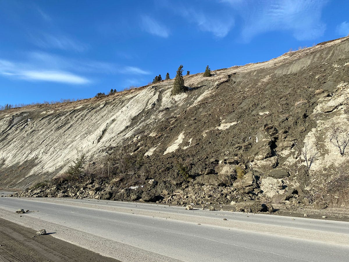
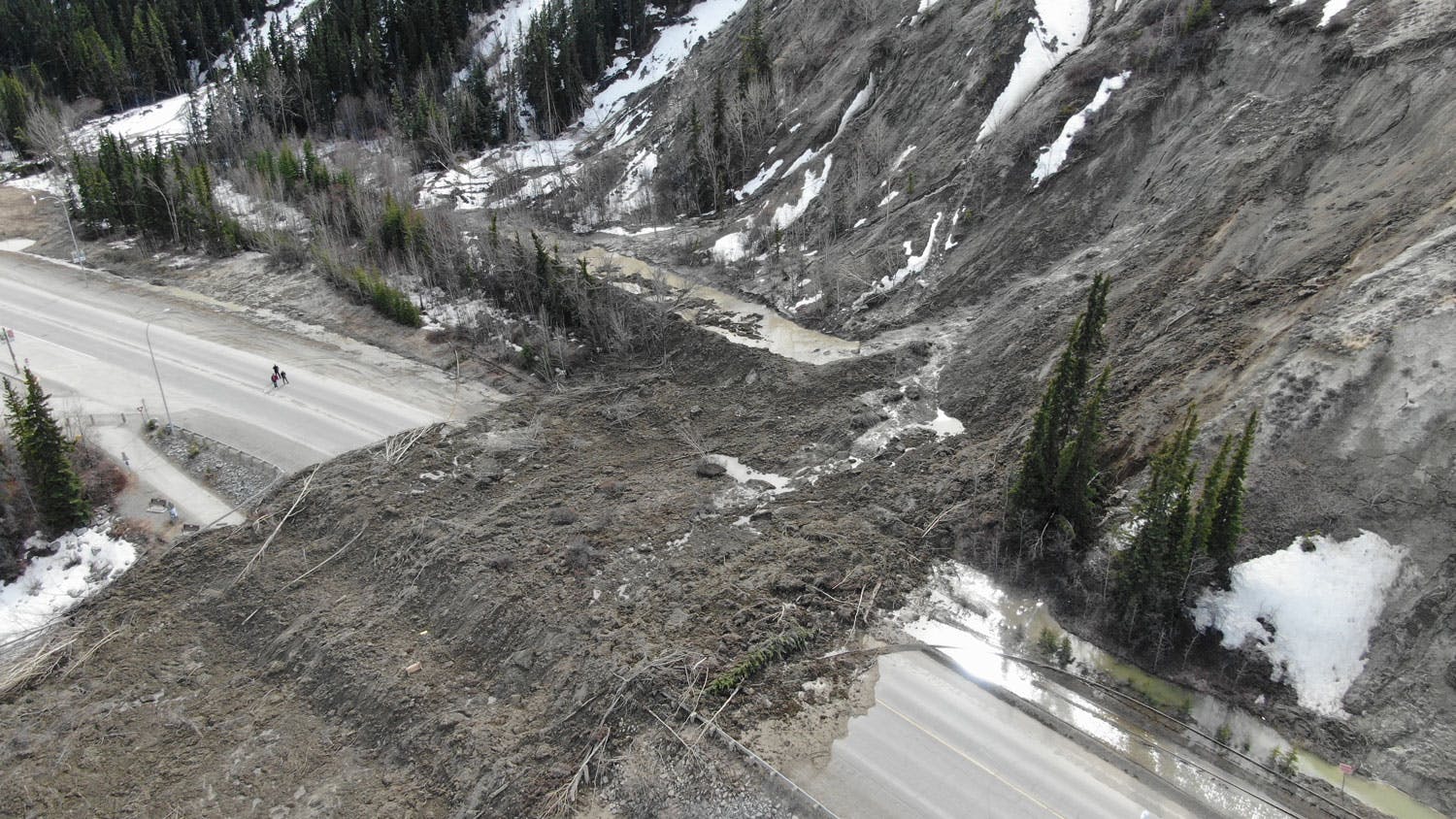
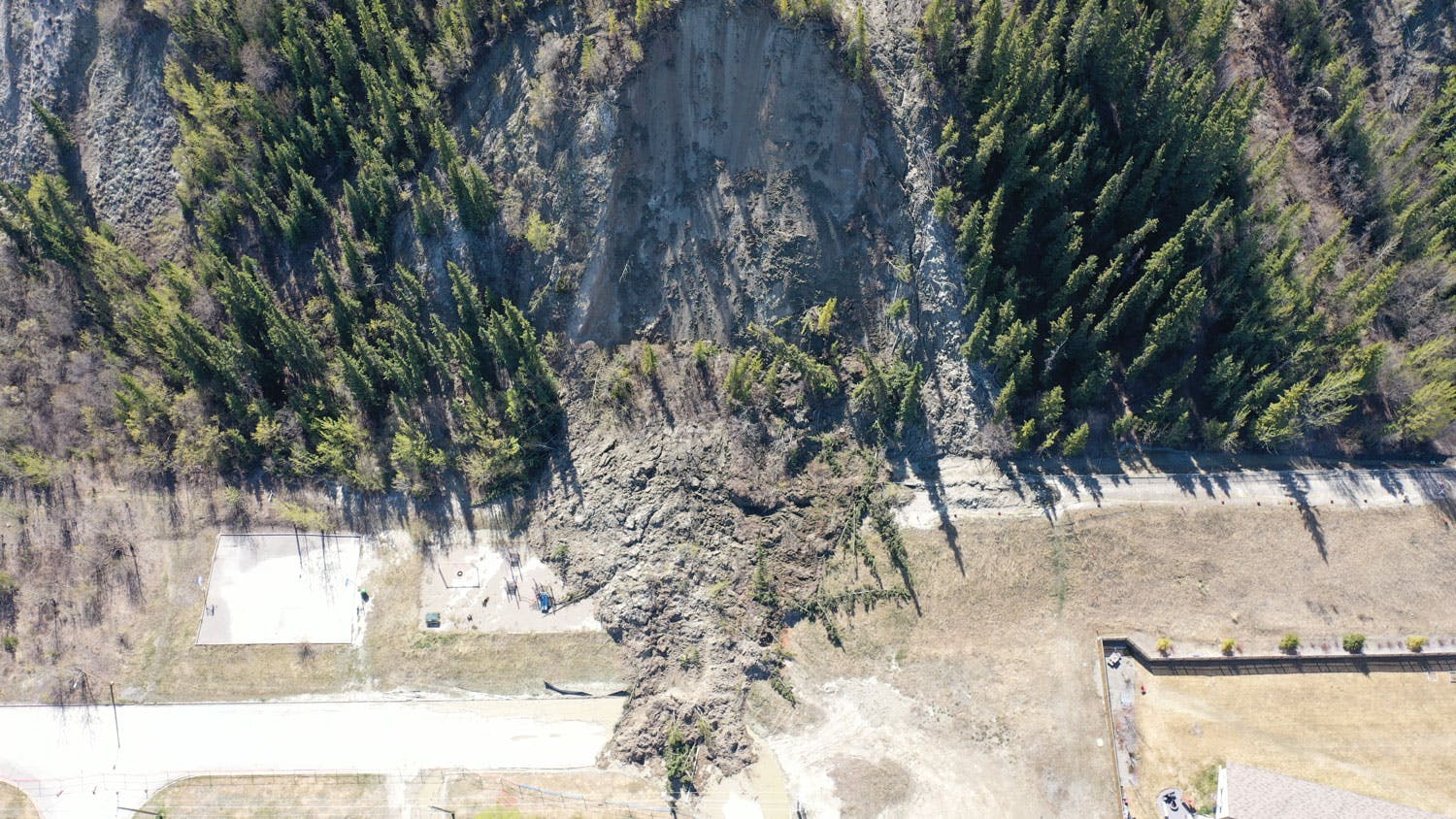
In 2022, a major landslide off the escarpment near Robert Service Way saw the closure of a major traffic artery into the City of Whitehorse. Visit out our FAQs and Glossary.
This year, the City is implementing a comprehensive monitoring program that will build on the work done in recent years, and provide additional data the City can use to develop short, interim and long term plans. Data will be gathered by a variety of methods including: visual inspections, targeted survey monitoring of critical slope areas, drone surveys, and slope monitoring for Robert Service Way.
There is a high potential for Robert Service Way, Millennium Trail and other trails along the base of the escarpment to experience partial or full closures during the 2023 freshet if geotechnical engineers recommend closure based on slope conditions. Closing roads and trails through Robert Service Way and along the escarpment is a decision that is not taken lightly. The City understands the impacts of such closures, however the closures may be required to mitigate the risks for the public.
In order to keep residents and visitors informed about the risk of a slide, the City will use a scale to determine what actions it takes to mitigate those risks.
Level 0 – no closures
Level 1 – partial closure of RSW and/or some trails
Level 2 – full closure of RSW and trails
Level 3 – full closure of RSW, trails and potential evacuation of key residents
During this year's freshet season, the City will be using a variety of tools to reach residents and keep them informed. To stay up to date, watch for updates below on this project page, and follow our social media channels on Facebook and Twitter.
Visit out our FAQs and Glossary.
As we enter spring, the City is working to plan for this year's snow melt and the 2023 freshet season.
In 2022, a major landslide off the escarpment near Robert Service Way saw the closure of a major traffic artery into the City of Whitehorse. Visit out our FAQs and Glossary.
This year, the City is implementing a comprehensive monitoring program that will build on the work done in recent years, and provide additional data the City can use to develop short, interim and long term plans. Data will be gathered by a variety of methods including: visual inspections, targeted survey monitoring of critical slope areas, drone surveys, and slope monitoring for Robert Service Way.
There is a high potential for Robert Service Way, Millennium Trail and other trails along the base of the escarpment to experience partial or full closures during the 2023 freshet if geotechnical engineers recommend closure based on slope conditions. Closing roads and trails through Robert Service Way and along the escarpment is a decision that is not taken lightly. The City understands the impacts of such closures, however the closures may be required to mitigate the risks for the public.
In order to keep residents and visitors informed about the risk of a slide, the City will use a scale to determine what actions it takes to mitigate those risks.
Level 0 – no closures
Level 1 – partial closure of RSW and/or some trails
Level 2 – full closure of RSW and trails
Level 3 – full closure of RSW, trails and potential evacuation of key residents
During this year's freshet season, the City will be using a variety of tools to reach residents and keep them informed. To stay up to date, watch for updates below on this project page, and follow our social media channels on Facebook and Twitter.
Visit out our FAQs and Glossary.
-
Share When will you adjust Hillcrest and airport traffic lights on the highway? Traffic backed up over 1 km headed north. Could not proceed through green airport light due to backed up cars from red Hillcrest traffic light. on Facebook Share When will you adjust Hillcrest and airport traffic lights on the highway? Traffic backed up over 1 km headed north. Could not proceed through green airport light due to backed up cars from red Hillcrest traffic light. on Twitter Share When will you adjust Hillcrest and airport traffic lights on the highway? Traffic backed up over 1 km headed north. Could not proceed through green airport light due to backed up cars from red Hillcrest traffic light. on Linkedin Email When will you adjust Hillcrest and airport traffic lights on the highway? Traffic backed up over 1 km headed north. Could not proceed through green airport light due to backed up cars from red Hillcrest traffic light. link
When will you adjust Hillcrest and airport traffic lights on the highway? Traffic backed up over 1 km headed north. Could not proceed through green airport light due to backed up cars from red Hillcrest traffic light.
Traffic jam asked about 3 years agoHi Traffic jam,
We want to assure you that our recent signal timing update aims to improve traffic flow and safety for all road users. We are closely monitoring the traffic conditions and assessing the changes' impact.
Our team is committed to ensuring that the traffic experience is as smooth and safe as possible for everyone. As we continue to monitor the situation, we will make further tweaks to the signal timing to optimize traffic flow and improve safety. We appreciate your patience and understanding during this process and encourage you to share any feedback or concerns you may have.
Thank you for sharing your concerns.
Adam Mickey, M.Eng., P.Eng.
Sr. Engineering Tech.
City of Whitehorse, Engineering Services
-
Share Vehicles that would otherwise be travelling on Robert Service Way are now contributing to increased congestion on the Alaska Highway near the Erik Nielsen International Airport, and comparing anecdotally, traffic originating from Hillcrest expecting to enter the Alaska Highway is low in volume. Beyond the adjustments to traffic signal timing at the intersections of Two Mile Hill and Range Road, and Two Mile Hill and the Alaska Highway to address West-East traffic, what consideration has the City of Whitehorse given to also adjusting the timing to traffic signals at the intersections of Hillcrest Drive and the Alaska Highway, and Burns Road and the Alaska Highway to improve South-North flow? Surely the City of Whitehorse began evaluating solutions in the spring of 2022 following a much more significant landslide, therefore what timelines can Whitehorse residents expect when advised that “the City is working towards understanding all potential options, then weighing those options to find the most cost effective and beneficial option to inform a future capital project for implementation”? Once the “most cost effective and beneficial option” has been identified by the City, when will that option be actioned? on Facebook Share Vehicles that would otherwise be travelling on Robert Service Way are now contributing to increased congestion on the Alaska Highway near the Erik Nielsen International Airport, and comparing anecdotally, traffic originating from Hillcrest expecting to enter the Alaska Highway is low in volume. Beyond the adjustments to traffic signal timing at the intersections of Two Mile Hill and Range Road, and Two Mile Hill and the Alaska Highway to address West-East traffic, what consideration has the City of Whitehorse given to also adjusting the timing to traffic signals at the intersections of Hillcrest Drive and the Alaska Highway, and Burns Road and the Alaska Highway to improve South-North flow? Surely the City of Whitehorse began evaluating solutions in the spring of 2022 following a much more significant landslide, therefore what timelines can Whitehorse residents expect when advised that “the City is working towards understanding all potential options, then weighing those options to find the most cost effective and beneficial option to inform a future capital project for implementation”? Once the “most cost effective and beneficial option” has been identified by the City, when will that option be actioned? on Twitter Share Vehicles that would otherwise be travelling on Robert Service Way are now contributing to increased congestion on the Alaska Highway near the Erik Nielsen International Airport, and comparing anecdotally, traffic originating from Hillcrest expecting to enter the Alaska Highway is low in volume. Beyond the adjustments to traffic signal timing at the intersections of Two Mile Hill and Range Road, and Two Mile Hill and the Alaska Highway to address West-East traffic, what consideration has the City of Whitehorse given to also adjusting the timing to traffic signals at the intersections of Hillcrest Drive and the Alaska Highway, and Burns Road and the Alaska Highway to improve South-North flow? Surely the City of Whitehorse began evaluating solutions in the spring of 2022 following a much more significant landslide, therefore what timelines can Whitehorse residents expect when advised that “the City is working towards understanding all potential options, then weighing those options to find the most cost effective and beneficial option to inform a future capital project for implementation”? Once the “most cost effective and beneficial option” has been identified by the City, when will that option be actioned? on Linkedin Email Vehicles that would otherwise be travelling on Robert Service Way are now contributing to increased congestion on the Alaska Highway near the Erik Nielsen International Airport, and comparing anecdotally, traffic originating from Hillcrest expecting to enter the Alaska Highway is low in volume. Beyond the adjustments to traffic signal timing at the intersections of Two Mile Hill and Range Road, and Two Mile Hill and the Alaska Highway to address West-East traffic, what consideration has the City of Whitehorse given to also adjusting the timing to traffic signals at the intersections of Hillcrest Drive and the Alaska Highway, and Burns Road and the Alaska Highway to improve South-North flow? Surely the City of Whitehorse began evaluating solutions in the spring of 2022 following a much more significant landslide, therefore what timelines can Whitehorse residents expect when advised that “the City is working towards understanding all potential options, then weighing those options to find the most cost effective and beneficial option to inform a future capital project for implementation”? Once the “most cost effective and beneficial option” has been identified by the City, when will that option be actioned? link
Vehicles that would otherwise be travelling on Robert Service Way are now contributing to increased congestion on the Alaska Highway near the Erik Nielsen International Airport, and comparing anecdotally, traffic originating from Hillcrest expecting to enter the Alaska Highway is low in volume. Beyond the adjustments to traffic signal timing at the intersections of Two Mile Hill and Range Road, and Two Mile Hill and the Alaska Highway to address West-East traffic, what consideration has the City of Whitehorse given to also adjusting the timing to traffic signals at the intersections of Hillcrest Drive and the Alaska Highway, and Burns Road and the Alaska Highway to improve South-North flow? Surely the City of Whitehorse began evaluating solutions in the spring of 2022 following a much more significant landslide, therefore what timelines can Whitehorse residents expect when advised that “the City is working towards understanding all potential options, then weighing those options to find the most cost effective and beneficial option to inform a future capital project for implementation”? Once the “most cost effective and beneficial option” has been identified by the City, when will that option be actioned?
YL asked about 3 years agoHi YL,
We are prioritizing signal timing modifications to AH/TMH and Range/TMH, as this is where most traffic concerns have been raised. We will continue to monitor traffic across the City for areas of improvement.
The long-term conceptual options analysis is nearly complete. The next step is to seek funding from the federal and territorial governments to support the long-term solution, which includes taking the chosen option to detailed design and construction. We expect detailed design to commence this year and work on the escarpment to begin in the next two years, but many factors could still affect this timeline. In the short to medium term, we continue to seek solutions that allow us more confidence to keep Robert Service Way open, such as the slope scanner implemented this year.
Thank you for your questions and interest in our 2023 escarpment response.
Adam Mickey, M.Eng., P.Eng.
Sr. Engineering Tech.
City of Whitehorse, Engineering Services
-
Share What is the city doing to address the sliding all along the escarpment from Robert Service Way to Marell? There have been slides Along the Takhini residential section to the point where you can see the houses. I have seen no mention of that and the risks for that area. on Facebook Share What is the city doing to address the sliding all along the escarpment from Robert Service Way to Marell? There have been slides Along the Takhini residential section to the point where you can see the houses. I have seen no mention of that and the risks for that area. on Twitter Share What is the city doing to address the sliding all along the escarpment from Robert Service Way to Marell? There have been slides Along the Takhini residential section to the point where you can see the houses. I have seen no mention of that and the risks for that area. on Linkedin Email What is the city doing to address the sliding all along the escarpment from Robert Service Way to Marell? There have been slides Along the Takhini residential section to the point where you can see the houses. I have seen no mention of that and the risks for that area. link
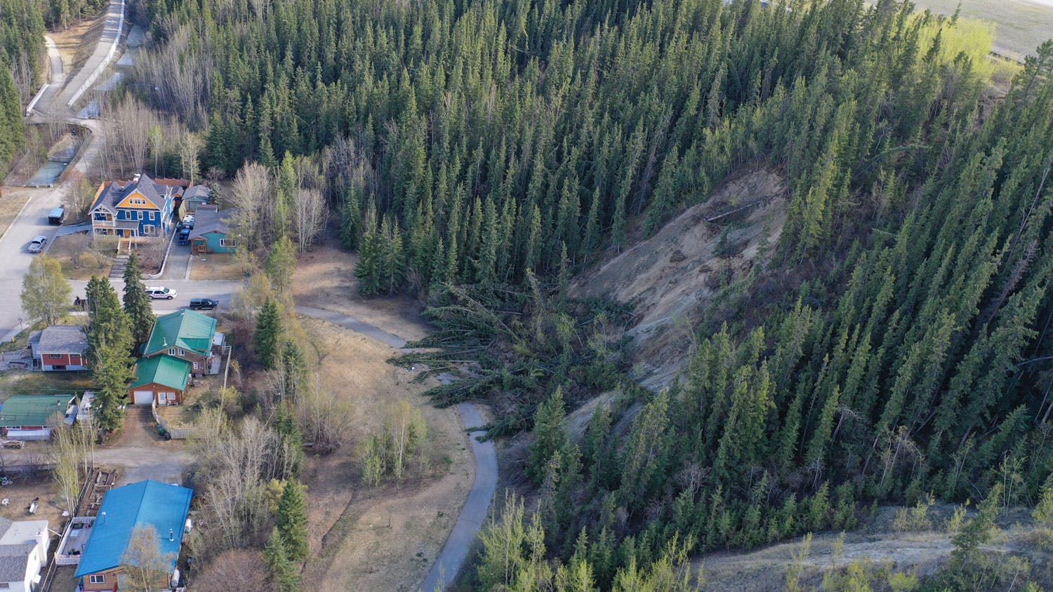
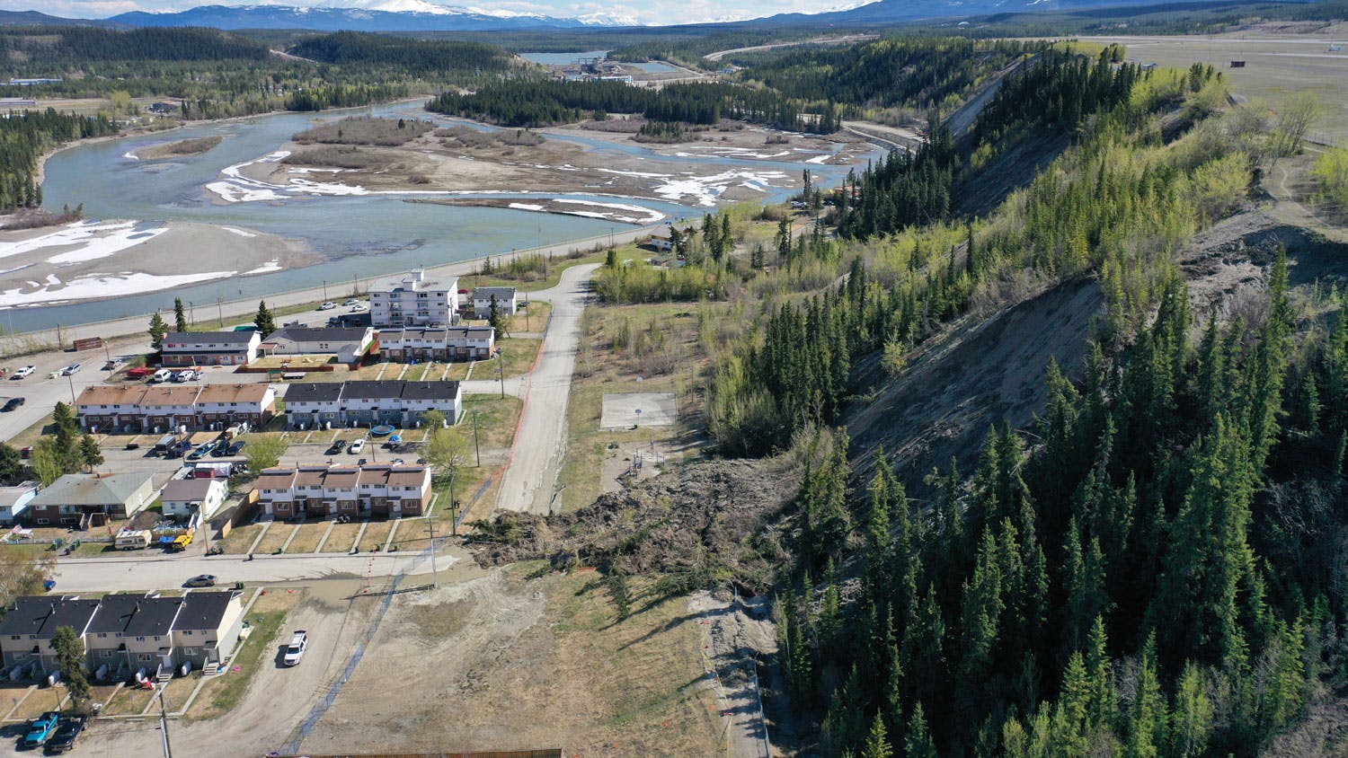
What is the city doing to address the sliding all along the escarpment from Robert Service Way to Marell? There have been slides Along the Takhini residential section to the point where you can see the houses. I have seen no mention of that and the risks for that area.
Ralph Heynen asked about 3 years agoHi Ralph.
The City’s geotechnical consultant is monitoring and assessing the risks of the escarpment from Robert Service Way to the Range Road/Mountainview Drive intersection, including Takhini. The most significant one prompted the construction and operation of the Takhini Trunk Sanitary emergency bypass.
The updated geohazard report currently being finalized includes the Takhini area. The City’s geotechnical consultant has indicated that there is no immediate risk to properties behind the crest or below the slope at this time. We are committed to continued studies to understand the escarpment, and we are looking to conduct a geohazard risk assessment of the whole escarpment in the near future.
Thank you for your question and bringing forth your concerns.
Adam Mickey, M.Eng., P.Eng.
Sr. Engineering Tech.
City of Whitehorse, Engineering Services
-
Share what discussions have taken place with the YG and Airport authorities about snow removal practices at the airport; surely with that magnitude of land mass and snow coverage, the removal, disposal and drainage of that volume of snow has got to be a factor in escarpment landslide risk management on Facebook Share what discussions have taken place with the YG and Airport authorities about snow removal practices at the airport; surely with that magnitude of land mass and snow coverage, the removal, disposal and drainage of that volume of snow has got to be a factor in escarpment landslide risk management on Twitter Share what discussions have taken place with the YG and Airport authorities about snow removal practices at the airport; surely with that magnitude of land mass and snow coverage, the removal, disposal and drainage of that volume of snow has got to be a factor in escarpment landslide risk management on Linkedin Email what discussions have taken place with the YG and Airport authorities about snow removal practices at the airport; surely with that magnitude of land mass and snow coverage, the removal, disposal and drainage of that volume of snow has got to be a factor in escarpment landslide risk management link
what discussions have taken place with the YG and Airport authorities about snow removal practices at the airport; surely with that magnitude of land mass and snow coverage, the removal, disposal and drainage of that volume of snow has got to be a factor in escarpment landslide risk management
Max Fraser asked about 3 years agoHi Max,
Airport snow practices have not changed significantly in recent times that would directly correlate that their practices are a driver of landslide initiation. 2021 and 2022 were extreme snowfall years well over historical averages, and around the Yukon, average groundwater levels have been increasing over time. We believe these are the two greatest factors affecting the escarpment in recent years.
The airport piles snow in four locations, one in the northern area along the highway, one in the terminal parking lot, and two in the general area across from the weigh scales. High-level groundwater analyses suggest that the northern snow dump will drain into Baxter’s Gulch, and the snow across from the weigh scales will drain into the Robert Service snow dump area because of a gully between it and the affected escarpment slopes. The City is, however, working with YG to further review the snow and ice control practices for the airport to ensure these practices are not a contributing factor.
Thank you for your question and engagement.
Adam Mickey, M.Eng., P.Eng.
Sr. Engineering Tech.
City of Whitehorse, Engineering Services
-
Share Due to the closure the traffic backs up entering and exiting 2 Mile Hill area onto/fr the Alaska Hwy for commuters. Given the potential and reality of south access closures in future, is there a plan to redesign and expand access via 2 Mile Hill as this has become a major bottleneck in the morning and end of working day? For example broadening the lanes to accommodate 2 turning lanes in either direction. I expect it is also problematic for emergency personal such as ambulance, fire, police etc to navigate during high intensity use timeframes. Also if there is a need for a mass evacuation ie wildland fire, egress is restricted by our current limited access to/fr the city core. on Facebook Share Due to the closure the traffic backs up entering and exiting 2 Mile Hill area onto/fr the Alaska Hwy for commuters. Given the potential and reality of south access closures in future, is there a plan to redesign and expand access via 2 Mile Hill as this has become a major bottleneck in the morning and end of working day? For example broadening the lanes to accommodate 2 turning lanes in either direction. I expect it is also problematic for emergency personal such as ambulance, fire, police etc to navigate during high intensity use timeframes. Also if there is a need for a mass evacuation ie wildland fire, egress is restricted by our current limited access to/fr the city core. on Twitter Share Due to the closure the traffic backs up entering and exiting 2 Mile Hill area onto/fr the Alaska Hwy for commuters. Given the potential and reality of south access closures in future, is there a plan to redesign and expand access via 2 Mile Hill as this has become a major bottleneck in the morning and end of working day? For example broadening the lanes to accommodate 2 turning lanes in either direction. I expect it is also problematic for emergency personal such as ambulance, fire, police etc to navigate during high intensity use timeframes. Also if there is a need for a mass evacuation ie wildland fire, egress is restricted by our current limited access to/fr the city core. on Linkedin Email Due to the closure the traffic backs up entering and exiting 2 Mile Hill area onto/fr the Alaska Hwy for commuters. Given the potential and reality of south access closures in future, is there a plan to redesign and expand access via 2 Mile Hill as this has become a major bottleneck in the morning and end of working day? For example broadening the lanes to accommodate 2 turning lanes in either direction. I expect it is also problematic for emergency personal such as ambulance, fire, police etc to navigate during high intensity use timeframes. Also if there is a need for a mass evacuation ie wildland fire, egress is restricted by our current limited access to/fr the city core. link
Due to the closure the traffic backs up entering and exiting 2 Mile Hill area onto/fr the Alaska Hwy for commuters. Given the potential and reality of south access closures in future, is there a plan to redesign and expand access via 2 Mile Hill as this has become a major bottleneck in the morning and end of working day? For example broadening the lanes to accommodate 2 turning lanes in either direction. I expect it is also problematic for emergency personal such as ambulance, fire, police etc to navigate during high intensity use timeframes. Also if there is a need for a mass evacuation ie wildland fire, egress is restricted by our current limited access to/fr the city core.
Nicola asked about 3 years agoHi Nicola,
The City of Whitehorse is not exploring options to upgrade/expand Two Mile Hill. Still, we are working on safety improvements for all users of the Range Road and Alaska Highway intersections along Two Mile Hill as part of the Transportation Master Plan. Please refer to the Transportation Master Plan Engage page for more information and keep an eye out for more details regarding Range Road and Alaska Highway intersection upgrades.
In the short term, the City is working with a transportation consultant to assess whether signal timing can be tweaked at Range Road and the Alaska Highway to help alleviate some of the traffic congestion.
The City regularly communicates with EMS, fire, and police to reduce impacts on their services.
We have considered the potential need for a mass evacuation of Downtown and/or Riverdale in the event of a wildfire or other disaster. The City is working with EMO and other organizations to develop an action plan for this situation.
Thank you for your constructive questions and concerns. These are all concerns that our staff and consultants are working hard to mitigate.
Adam Mickey, M.Eng., P.Eng.
Sr. Engineering Tech
City of Whitehorse, Engineering Services
-
Share Given the current evidence of instabilities, what I have not read in the FAQs is the impact of an earthquake in regard to the clay cliffs in particular south access and areas where residents may be in harms path. Just a few years ago there was a significant spring earth quake. Has a risk assessment been done for this type of very real potential occurrence? on Facebook Share Given the current evidence of instabilities, what I have not read in the FAQs is the impact of an earthquake in regard to the clay cliffs in particular south access and areas where residents may be in harms path. Just a few years ago there was a significant spring earth quake. Has a risk assessment been done for this type of very real potential occurrence? on Twitter Share Given the current evidence of instabilities, what I have not read in the FAQs is the impact of an earthquake in regard to the clay cliffs in particular south access and areas where residents may be in harms path. Just a few years ago there was a significant spring earth quake. Has a risk assessment been done for this type of very real potential occurrence? on Linkedin Email Given the current evidence of instabilities, what I have not read in the FAQs is the impact of an earthquake in regard to the clay cliffs in particular south access and areas where residents may be in harms path. Just a few years ago there was a significant spring earth quake. Has a risk assessment been done for this type of very real potential occurrence? link
Given the current evidence of instabilities, what I have not read in the FAQs is the impact of an earthquake in regard to the clay cliffs in particular south access and areas where residents may be in harms path. Just a few years ago there was a significant spring earth quake. Has a risk assessment been done for this type of very real potential occurrence?
Nicola asked about 3 years agoHi Nicola,
The City retained the services of a specialized geotechnical engineering firm to complete a geohazard study in 2002 and is currently being updated. This study established geohazard zones that guide development along the escarpment. The 2002 geohazard report assessed the seismic loading of the slopes and assessed that the slopes would be resistant to deep-seated failures during an earthquake. A seismic event could trigger the types of shallow failures that have occurred since 2021; however shallow failures should not result in adverse impacts to structures. The City has also taken steps to protect life and property since the 2002 study by expropriating susceptible properties if slope failures occurred. All new development in the moderate hazard zone must have a site-specific geohazard analysis performed and mitigation measures employed to protect the structures if required.
The City is looking to conduct a geohazard risk analysis for the entire escarpment in the near future, which will consider a seismic event.
Thank you for highlighting the risks of an earthquake and asking a constructive question for all to read.
Adam Mickey, M.Eng., P.Eng.
Sr. Engineering Tech
City of Whitehorse, Engineering Services
-
Share Why are we not initiating a slide with a controlled instigator such as an explosive blast, water cannon or otherwise, inorder to provoke weak and loose material to move, therefore eradicating the issue!? Miles of traffic leading to the now 1 and only route to downtown AND OUR ONLY HOSPITAL should be considered by the city as completely unacceptable. Much like the observation time-line the city is currently budgeting. British columbia would have had this dealt with on the same day as the slide. I further request consideration to re-open the dam crossing to lighten the absolutely ridiculous traffic load. Please and thank you on Facebook Share Why are we not initiating a slide with a controlled instigator such as an explosive blast, water cannon or otherwise, inorder to provoke weak and loose material to move, therefore eradicating the issue!? Miles of traffic leading to the now 1 and only route to downtown AND OUR ONLY HOSPITAL should be considered by the city as completely unacceptable. Much like the observation time-line the city is currently budgeting. British columbia would have had this dealt with on the same day as the slide. I further request consideration to re-open the dam crossing to lighten the absolutely ridiculous traffic load. Please and thank you on Twitter Share Why are we not initiating a slide with a controlled instigator such as an explosive blast, water cannon or otherwise, inorder to provoke weak and loose material to move, therefore eradicating the issue!? Miles of traffic leading to the now 1 and only route to downtown AND OUR ONLY HOSPITAL should be considered by the city as completely unacceptable. Much like the observation time-line the city is currently budgeting. British columbia would have had this dealt with on the same day as the slide. I further request consideration to re-open the dam crossing to lighten the absolutely ridiculous traffic load. Please and thank you on Linkedin Email Why are we not initiating a slide with a controlled instigator such as an explosive blast, water cannon or otherwise, inorder to provoke weak and loose material to move, therefore eradicating the issue!? Miles of traffic leading to the now 1 and only route to downtown AND OUR ONLY HOSPITAL should be considered by the city as completely unacceptable. Much like the observation time-line the city is currently budgeting. British columbia would have had this dealt with on the same day as the slide. I further request consideration to re-open the dam crossing to lighten the absolutely ridiculous traffic load. Please and thank you link
Why are we not initiating a slide with a controlled instigator such as an explosive blast, water cannon or otherwise, inorder to provoke weak and loose material to move, therefore eradicating the issue!? Miles of traffic leading to the now 1 and only route to downtown AND OUR ONLY HOSPITAL should be considered by the city as completely unacceptable. Much like the observation time-line the city is currently budgeting. British columbia would have had this dealt with on the same day as the slide. I further request consideration to re-open the dam crossing to lighten the absolutely ridiculous traffic load. Please and thank you
Reid asked about 3 years agoHi Reid,
The City of Whitehorse is looking into ways to initiate some of the slides using a variety of methods. However, there are other impacts that must be taken into consideration, including the risk of destabilizing more areas, and using water brings a host of environmental concerns and permitting requirements due to the proximity of the Yukon River.
We regularly communicate with EMS and the fire department to ensure they can deliver their services without interruptions.
The escarpment slopes cannot be compared to the events in British Columbia because they are different types of landslides. British Columbia commonly sees debris flow events. Once these events occur, there is little material left to cause another event that could impact the vehicle travelling on the road. Also, extensive mitigation structures have been designed and implemented that mitigate debris flows that the public cannot see while travelling the highway system.
The dam cannot support the traffic volumes of Robert Service Way. The dam crossing is reserved for emergencies and has never been opened for public access to Riverdale.
Thank you for your questions.
Adam Mickey, M.Eng., P.Eng.
Sr. Engineering Tech
City of Whitehorse, Engineering Services
-
Share What if anything is the long term plan for the area obviously temporary pilings is not the answer long term is it possible to stabilize the cliffs with excavation or is there another way to mitigate this from happening in the future or is it time to think of an alternative route. Or plan to close RSW every spring on Facebook Share What if anything is the long term plan for the area obviously temporary pilings is not the answer long term is it possible to stabilize the cliffs with excavation or is there another way to mitigate this from happening in the future or is it time to think of an alternative route. Or plan to close RSW every spring on Twitter Share What if anything is the long term plan for the area obviously temporary pilings is not the answer long term is it possible to stabilize the cliffs with excavation or is there another way to mitigate this from happening in the future or is it time to think of an alternative route. Or plan to close RSW every spring on Linkedin Email What if anything is the long term plan for the area obviously temporary pilings is not the answer long term is it possible to stabilize the cliffs with excavation or is there another way to mitigate this from happening in the future or is it time to think of an alternative route. Or plan to close RSW every spring link
What if anything is the long term plan for the area obviously temporary pilings is not the answer long term is it possible to stabilize the cliffs with excavation or is there another way to mitigate this from happening in the future or is it time to think of an alternative route. Or plan to close RSW every spring
Darcy asked about 3 years agoHi Darcy,
The City of Whitehorse is exploring many long-term options for Robert Service Way, with an options analysis conducted by our geotechnical consultant currently in draft form. We expect the assessment to be finalized soon. The options analysis explores many ways to stabilize the escarpment along Robert Service Way to allow the City to weigh all the options to find the most cost-effective and beneficial one to inform a future capital project for implementation.
The City is working hard to expedite the long-term solution as well as find short-term solutions that help reduce the impacts to Robert Service Way. One short-term mitigation measure we are implementing this year is a radar-based slope scanner that continuously surveys the slopes along the roadway.
Thank you for your interest and for sharing your ideas.
Adam Mickey, M.Eng., P.Eng.
Sr. Engineering Tech.
City of Whitehorse, Engineering Services
-
Share Has anyone examined resloping the clay cliffs? I.e. cutting the top back so the entire slope is at 1:1 or less; then installing engineered retaining walls/terraces; then planting those terraces with deep rooted plants? on Facebook Share Has anyone examined resloping the clay cliffs? I.e. cutting the top back so the entire slope is at 1:1 or less; then installing engineered retaining walls/terraces; then planting those terraces with deep rooted plants? on Twitter Share Has anyone examined resloping the clay cliffs? I.e. cutting the top back so the entire slope is at 1:1 or less; then installing engineered retaining walls/terraces; then planting those terraces with deep rooted plants? on Linkedin Email Has anyone examined resloping the clay cliffs? I.e. cutting the top back so the entire slope is at 1:1 or less; then installing engineered retaining walls/terraces; then planting those terraces with deep rooted plants? link
Has anyone examined resloping the clay cliffs? I.e. cutting the top back so the entire slope is at 1:1 or less; then installing engineered retaining walls/terraces; then planting those terraces with deep rooted plants?
Yukoner2000 asked about 3 years agoHi Yukoner2000,
Reshaping the escarpment to a constant, shallower angle is one option our geotechnical consultants are exploring as part of the City’s long-term options analysis in the Robert Service Way area. A terraced slope with retaining walls is another option being considered as well. The options analysis is still in development and draft at the moment, and we expect to finalize this assessment soon.
Thank you for your interest and sharing your ideas.
Cheers,
Adam Mickey, M.Eng., P.Eng.
Sr. Engineering Tech.
Engineering Services, City of Whitehorse
-
Share Hi, Somewhere along the way it was suggested that there be a concrete tunnel built along that stretch of the highway much like the Fraser highway in BC (I think it is the Fraser anayway) and I am curious if that would work and if not, why not? I am obviously not an expert in this area! on Facebook Share Hi, Somewhere along the way it was suggested that there be a concrete tunnel built along that stretch of the highway much like the Fraser highway in BC (I think it is the Fraser anayway) and I am curious if that would work and if not, why not? I am obviously not an expert in this area! on Twitter Share Hi, Somewhere along the way it was suggested that there be a concrete tunnel built along that stretch of the highway much like the Fraser highway in BC (I think it is the Fraser anayway) and I am curious if that would work and if not, why not? I am obviously not an expert in this area! on Linkedin Email Hi, Somewhere along the way it was suggested that there be a concrete tunnel built along that stretch of the highway much like the Fraser highway in BC (I think it is the Fraser anayway) and I am curious if that would work and if not, why not? I am obviously not an expert in this area! link
Hi, Somewhere along the way it was suggested that there be a concrete tunnel built along that stretch of the highway much like the Fraser highway in BC (I think it is the Fraser anayway) and I am curious if that would work and if not, why not? I am obviously not an expert in this area!
Koolkat13 asked about 3 years agoHi Koolkat13,
British Columbia has multiple avalanche sheds on its highways. A covered roadway or elevated roadway are two potential solutions being explored by the City’s geotechnical consultant for long-term landslide mitigation at the preliminary ideas stage to understand all possible solutions. A structure could be designed to allow landslide debris to flow overtop of or below Robert Service Way, but it would be one of the most expensive options. At this time, the City is working towards understanding all potential options, then weighing those options to find the most cost effective and beneficial option to inform a future capital project for implementation.
Thank you for your interest and sharing your ideas.
Cheers,
Adam Mickey, M.Eng., P.Eng.
Sr. Engineering Tech.
Engineering Services, City of Whitehorse
Who's Listening
-
TE
-
TA
Photos
Videos
-
Click here to play video Groundwater exiting the escarpment - April 19, 2023 The escarpment along Robert Service Way continues to show signs of movement at the location of the April 8 slide while the rest of the escarpment is very active.
-
Click here to play video Dry slide which occurred the last week of April 2023 Video taken during a site visit by our Engineering team. They caught this ‘dry slide’ on video as it was happening.
Timeline
-
Preparations
Escarpment 2023 has finished this stage -
Freshet
Escarpment 2023 is currently at this stageSpring 2023 - Summer 2023
-
Post-response
this is an upcoming stage for Escarpment 2023
